
RASTA – Navigations, Speedometers, Nearby Locations, City Places
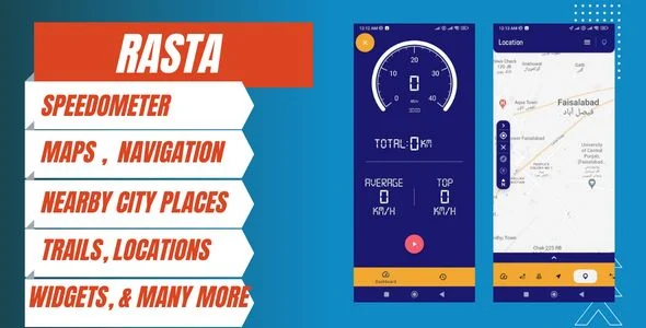
RASTA Navigation & Speedometer Android App Overview & Position-Aware Mobile Architecture
RASTA Navigation & Speedometer Android App is a native Android source package engineered for mobile developers and app agencies to ship GPS-driven location, routing, and speed-tracking experiences targeting Android 12.0 devices. The codebase consolidates five previously fragmented positioning workloads — GPS location tracking, turn-by-turn destination routing, direction finding, speed measurement, and nearby city-place discovery — into one distributable .apk build. Within agency delivery pipelines, it functions as a rebrandable foundation for location-utility apps aimed at drivers, commuters, and travelers navigating unfamiliar cities.
Technical Specifications & Deployment Matrix
| Engineering Metric | Deployment Specification |
|---|---|
| Base Technology / Framework | Native Android application codebase |
| Runtime / Language Requirements | Android 12.0 software baseline |
| Distribution Artifact | Compiled .apk file included for direct device installation |
| Data Exchange / Communication Protocols | GPS satellite positioning input; location-data queries for nearby venue metadata |
| Monetization Layer | AdMob and Facebook Ads networks pre-wired into the delivery layer |
| Database / Persistence Footprint | On-device client storage for markers, trails, and widget state |
GPS Positioning Pipeline & Multi-Module Execution Flow
The pipeline anchors on a GPS positioning listener streaming live device coordinates into four coordinated functional modules. On startup, the runtime requests location access, acquires a satellite fix, and parses the resulting coordinate payload before dispatching it across the rendering layer. The map surface consumes those coordinates to plot current position, while a parallel query path resolves nearby city places — restaurants, gas stations, cafes, and attractions — and decorates each result with operational metadata such as hours of operation and customer reviews. When a user submits a destination, the routing engine computes the most efficient path and emits turn-by-turn directions, a branch that also covers direction-finding scenarios where drivers must steer around road closures or traverse unfamiliar districts. The speedometer module derives current velocity from the same positional feed, giving drivers a live readout for legal speed-limit compliance without dedicated hardware. Trail recording, marker persistence, clock display, and home-screen widgets round out the on-device data layer, all coordinated through a single location event stream rather than competing sensor loops. For studios assembling a broader Android catalog, Gallery exists as a separate photo-management codebase for decoupled implementations outside the positioning stack.
Architectural & Functional Capabilities of RASTA
- GPS Location Tracking Engine: Converts satellite fixes into rendered map positions plotted alongside nearby points of interest, so one event stream drives both self-location and contextual discovery output.
- Turn-by-Turn Navigation Router: Accepts user-defined destination input, calculates the most efficient route, and emits sequential direction steps suited to unfamiliar areas and road-closure detours.
- Live Speedometer Module: Derives vehicle velocity from the positional feed, enabling continuous speed-limit monitoring while driving.
- Nearby City-Place Discovery: Resolves surrounding venues and attaches hours of operation plus customer reviews to each discovered location for decision-ready metadata.
- Dual-Network Ad Monetization: Ships with both AdMob and Facebook Ads wired in, reducing release work to publisher configuration rather than SDK integration.
Production Implementation & Operational Resilience
Production rollout targets the Android 12.0 baseline, and the shipped .apk artifact lets QA teams validate positioning accuracy, route computation, and ad rendering on physical hardware before a signed store build is assembled. Every GPS-dependent module shares a common environmental threshold: an active satellite fix. Indoor spaces, dense urban canyons, and weak-signal regions degrade coordinate accuracy, which cascades into the speedometer readout and the nearby-place discovery radius, so staging tests should cover both open-sky and degraded-signal conditions. Runtime location permissions must be granted before the listener dispatches coordinates, and the permission-denial path deserves explicit exercise during pre-release verification. White-label delivery is handled through the standard rebranding vectors — application name, launcher logo, and package identifier — leaving the positioning logic untouched. Monetization configuration reduces to replacing ad unit identifiers for the two networks already present in the codebase; teams running parallel casual-game releases can evaluate Magic Hero Adventure as an independent AdMob-ready Android build outside this navigation runtime. Because the nearby-place module depends on external location data for venue details, hours, and reviews, upstream feed changes can affect discovery output independently of on-device logic — a boundary worth monitoring between release cycles.
Frequently Asked Questions
Does the package include a compiled APK for direct device testing?
Yes — the deliverable ships with an .apk artifact, allowing installation on Android 12.0 hardware without an intermediate build step, so QA can validate GPS behavior and ad rendering before store submission.
Are both AdMob and Facebook Ads integrated into the monetization layer?
Yes — the codebase ships with both ad networks already wired into the delivery layer, requiring only publisher identifier and placement configuration during the store-release build to activate revenue streams.
Does nearby-place discovery surface operational details beyond basic map pins?
Yes — the module pulls data covering hours of operation and customer reviews for discovered venues such as restaurants, gas stations, and cafes, enriching each location with decision-ready metadata.
Does the app compute a route after a user enters a custom destination?
Yes — destination input triggers the routing engine, which returns turn-by-turn directions along the most efficient route, supporting navigation around obstacles such as road closures in unfamiliar areas.
Sticker Maker for WhatsApp – Stickers in WhatsApp – Sticker Maker-WhatsApp – Sticker Maker for WA

Minecraft McAddon Template Project|Create McAddon Android App

ProZigzagBus : Online Multi Vendor Bus Ticket Booking App & Reservation System Flutter Solution